Artificial intelligence platform for the territory
The intelligence that sees the entire territory.
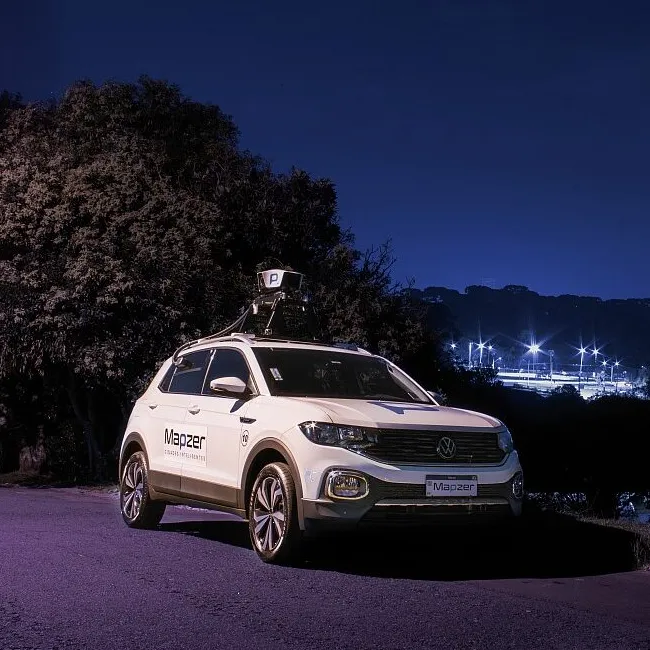
Mapzer travels roads and public space with onboard AI, detects and classifies dozens of types of occurrence and delivers everything in a management dashboard. For those who operate territory, from the public sector to private companies.
occurrences detected across the Americas and Europe
monitored · equivalent to 16 times around the world
types of occurrence recognized by AI
of real-world operation
In action
See Mapzer from the inside.
From capture on the street to the alert on the dashboard, in just minutes.
Who it is for
Built for those who operate the territory, from the public sector to the private one.
Municipal, state and federal governments, highway operators and companies with their own roads.
The challenge
Operating a large territory is hard without seeing everything.
Vast territory
Kilometers of roads and very different areas, hard to cover by eye.
Scattered data
Occurrences and requests arrive through multiple channels, with no tracking.
Decisions without a map
Maintenance and oversight without an up-to-date view of everything.
Purely corrective management
Most of the effort is reactive, not preventive.
The technology
Everything the operation needs, in one place.
Decide with data and demonstrate it to whoever needs to see it.
Real time
Interactive map with every occurrence across the territory.
Visual proof
Each problem with a photo and georeferenced location.
Reports
Data by type of occurrence, period and region.
Segmentation
Each team sees only what falls under its remit.
Prioritization
Occurrences ranked by risk criteria.
History
A complete record of every intervention carried out.
360° management
More than roads. The entire public space.
Mapzer detects and maps four management areas at the same time.
Road infrastructure
- Potholes and cracks
- Drainage problems
- Missing covers
Signage & safety
- Damaged signs
- Faulty street lights
- Degraded sidewalks
Urban cleaning
- Illegal waste
- Invasive vegetation
- Blocked gutters
Mobility & traffic
- Illegal parking
- Obstructed roads
- Reduced accessibility
Efficiency & savings
Up to 88% savings on territory inspection.
Teams driving the roads are expensive and see little. Mapzer covers the whole network, all the time, for a fraction of that cost.
Reduces the cost of repair by acting early.
Avoids incidents and compensation claims.
Based on real data, not on pressure.
Strengthens the trust of those who oversee and those who use the road.
Responsible use
Intelligent. And legitimate.
Governance and data protection (GDPR) at every step.
Purpose
Data collected for a clear and defined purpose.
Minimization
Faces and license plates automatically blurred.
Transparency
It is clear what is collected and why.
Auditing
Access records verifiable by those with the authority to do so.
Security
Encryption in transit and at rest, with controlled access.
GDPR
Data Protection Officer (DPO) integrated.
How to start
Visible results as early as the first quarter.
Diagnosis
Mapping with vehicles and a baseline diagnosis of the territory.
Pilot
Platform live in one region, with impact indicators.
Expansion
Rollout to the entire operation and integration with internal systems.
Operation
Permanent monitoring, monthly reports and new features.
Frequently asked questions
Frequently asked questions
What is road mapping with artificial intelligence?
It is the use of cameras and sensors mounted on vehicles, combined with artificial intelligence, to travel the roads and automatically identify problems such as potholes, cracks, damaged signage and illegal dumping. Mapzer turns these images into georeferenced data inside a management dashboard.
How can potholes and pavement defects be detected automatically?
Vehicles equipped with Mapzer technology drive along the roads, and the artificial intelligence recognizes and classifies pavement defects, with a photo and exact location, without relying on manual inspection or on complaints from users.
How can the cost of road inspection and maintenance be reduced?
By replacing manual patrols with continuous monitoring through artificial intelligence, which covers the entire road network for a fraction of the cost. Identifying defects early enables preventive maintenance and prevents small problems from turning into expensive repairs.
What types of occurrence does Mapzer detect on roads and in public space?
More than 48 types of situation, organized into four areas: road infrastructure, signage and safety, urban cleaning, and mobility and traffic. This includes potholes, cracks, drainage issues, damaged signs and lighting, illegal dumping, invasive vegetation and illegal parking.
Does Mapzer serve city halls, state governments and highway concessionaires?
Yes. Mapzer serves municipal, state and federal governments as well as highway concessionaires, adapting the mapping to the network of each operation, from the city to the highways that connect entire regions.
Can private companies with their own roads use Mapzer?
Yes. Industries, mining companies, ports and logistics firms use Mapzer to monitor internal roads, yards and access points, with the same intelligence applied to public space.
Is camera-based road monitoring compliant with the GDPR?
Yes. Mapzer automatically blurs faces and license plates, collects data for a defined purpose, keeps everything encrypted and has a Data Protection Officer (DPO). The focus is the problem on the road, not the person.
Do you need to buy vehicles or equipment to use Mapzer?
Not necessarily. The solution can operate with Mapzer's own fleet or make use of vehicles that already run through your operation, without requiring an upfront investment in equipment.
How long does it take to implement and see results?
Implementation happens in phases: diagnosis in about 30 days, pilot in 60 and expansion in 90, with impact indicators visible as early as the first quarter of operation.
How does artificial intelligence help in managing smart cities?
It gives the manager an up-to-date view of the entire territory, prioritizes what is most urgent by risk criteria and generates evidence for decisions and accountability, making maintenance preventive rather than merely corrective.
Ready to operate your territory with data and AI?
Schedule a demo and receive a sample diagnosis of your territory.